As discussed in the Philosophy Blog this model can be defined as prototype freelanced.. Fortunately or not defined infrastructure was constructed at Spicers Creek and as this is the first of the modules it is appropriate to examine what exist and its effect on the stage sets design.
 |
| Area and features to be modeled |
The original line was a proposal attached to the construction of the Denman line which if all the infrastructure had been constructed would have made Sandy Hollow to Denman a branch line with the Sandy Hollow - Guglong - Mary Vale a secondary main at least across the heart of the state. The key to the final construction of the Sandy Hollow branch was the existence of coal and today is the reason for the line's continued existence.
The area of Spicers Creek is currently rich in farming mainly cattle and sheep so this will be used to create additional traffic on the line. The development of a history is part of of the philosophy that develops constrains for the model to operate in. The integration of the existing infrastructure defines the infrastructure that will be modeled, trackage layout and scenery used in a individual stage set.
 |
| Bridge Pylon Maryvale side Goomla Road |
 |
Bridge Pylon Gulgong side Goomla Road
|
These bridge pylons are a must model feature for the Spicers Creek stage set as they a located on Goomla Road and will anchor the model into the real world. The bridge will be a 24 foot deck girder bridge from Waratah Models.
 |
Drainage near bridge abutments
Examination of the existing infrastructure shows that drainage culverts were spaced about every 500 meters along all the embankments which have stood the test of time and for this reason and are a must model feature. The one shown are located just after the pylons and are a must have.
|
 |
| Embankment Mary Vale side |
This photo shows a grove of trees in the distance that cross a small creek. This will be handy to disguise the set entry along with the rows populars along the road side near pylon. These are located on the aisle side on the model and should form a nice view block thought a lot of selective compression will have to be applied.
 |
Embankment Gulgong side
|
These two shots were taken looking back from the pylon to Gulgong. The area is accessed from the Cemetery Road..
 |
| Right of way Gulgong side |
Points of interest at Spicers Creek
 |
Church Gulgong side
|
The church history is unknown but if room is available would provide another anchor for the model set. The old cemetery would be an ideal model as it appears to be a pioneer site. Access is not available as it is now on fenced land but is a definite must model as it is so small.

Stage Set after field research.
Spicers Creek station would have been located about 1 km up the line from the bridge on the Mary Vale side based on the research information prepared by Chris Wangmann. Model railways modelers tend to want to fill all scenes with as much infrastructure as possible for switching and other reasons but this dose not allow operators to get a sense of travel if moving from one station to another.
Spicers Creek station would have been located about 1 km up the line from the bridge on the Mary Vale side based on the research information prepared by Chris Wangmann. Model railways modelers tend to want to fill all scenes with as much infrastructure as possible for switching and other reasons but this dose not allow operators to get a sense of travel if moving from one station to another.
Sometimes less can be more..!
After examining Chris Wangmann article and the track diagrams for Spicers Creek it would featured a passing siding with cattle yard. Drill Creek is a major station so the Spicers Creek would be a running stage set built around the existing bridge abutment's to create that sense of distance when traveling between Drill Creek and Goomla.
 |
| To view in larger format - double click - then select image |
Creek Crossing
Studying the tree line along the creek line seen from the Mary vale side of the abutments it was envisioned that 3 span deck girder bridge of a total length 72 foot would be incorporated in the model.
On the second trip to measure the abutments for modeling and knowing the way to the creek side it was decided to try and photograph area. After carefully scaling barbed wire farm fences the reality did not meet the mental picture.
 |
| The image of what the modeler wanted to see [Chris Wangman photo] |
On the second trip to measure the abutments for modeling and knowing the way to the creek side it was decided to try and photograph area. After carefully scaling barbed wire farm fences the reality did not meet the mental picture.
Instead of seeing a wide slow moving creek I was confronted with a dry creek bed and a large single concrete culvert - the mental picture popped! It was a salient lesson in how our ideas are always grander than the simplicity of the prototype.
A quick walk through the culvert to the other side revealed the damage that this design approach created over time, proof of its inadequate nature. The culvert outlet has cut a vertical canyon a 10 - 12 meters deep with the outlet of the culvert eroded away creating a vertical drop of 3 meters at the exit undercutting the culvert floor. The damage is clearly the result of a single culvert with a huge load of water created by the embankment with a single outlet through the culvert equals huge water velocity at the outlet with the spectacular erosion created.
 |
| The reality behind the tree line |
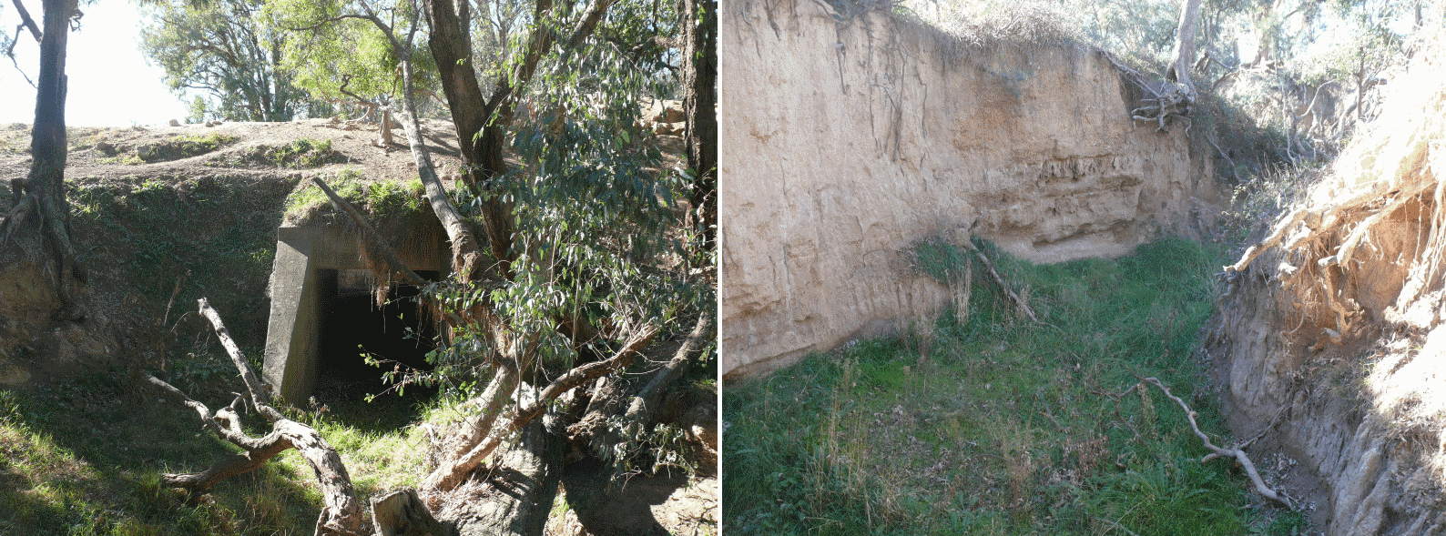 |
| Culvert at entry Culvert at Exit |
The question is how to model the scene as the mind saw it or the cold reality. What is in no doubt is that if the line was constructed at least two more culverts would have been added to reduce water velocity but would they have been concrete - tubular metal culverts or maybe the illusion is just better modeling....!
The photo above of the girder bridge located near Mebul Road and is what the modeler mind created for the crossing - now maybe if the piers are a little lower...!
18/1/13 - Page revised in light of new information received on the line
16/6/13 - Culvert chapters added
16/6/13 - Culvert chapters added
No comments:
Post a Comment